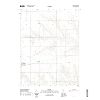
2018 Map of McDonald
USGS Topo · Published 2018About this map
McDonald anchors this portion of Rawlins County, situated along the southern edge of the survey where the local street grid includes Republic St, Lincoln St, and Norton St. This small agricultural settlement is serviced by a central Po and sits just south of the Jack Poore Airport. The landscape is defined by the winding paths of N Beaver Cr and Little Beaver Cr, which have carved intricate drainage patterns through the High Plains terrain. These watercourses create a distinct contrast between the flat upland agricultural sections and the complex topography of the creek breaks. The map illustrates the 2018 configuration of rural section roads, such as Rd V and Rd U, which maintain the rigid geometric order typical of the Public Land Survey System even as the natural hydrology of the Beaver Creek tributaries cuts across the grid.
Find a feature on this map
15 named features on this map. Tap any name to fly to it.
Don’t see what you’re looking for? This feature index may not catch every label — zoom into the map to look around manually.
Map Details
Editions of this 2018 McDonald Map
This is the sole edition of this map. No revisions or reprints were ever made.
Other maps of this area

1950 · Mc Donald
USGS Topo · 1:62,500

1951 · Mc Donald
USGS Topo · 1:62,500

1951 · Atwood
USGS Topo · 1:62,500

1951 · Chardon
USGS Topo · 1:62,500

1951 · Dewey Ranch
USGS Topo · 1:62,500

1954 · Goodland
USGS Topo · 1:250,000

1956 · Goodland
USGS Topo · 1:250,000

1957 · Goodland
USGS Topo · 1:250,000
1978 · Beardsley
USGS Topo · 1:24,000
1978 · Mc Donald NW
USGS Topo · 1:24,000