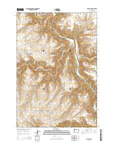
2014 Map of McDonald
USGS Topo · Published 2014About this map
John Day River carves a deep, winding path through the basalt plateaus of Sherman and Gilliam counties, defining the remote character of this landscape. Near the river's bend, the small settlement of McDonalds serves as a focal point in a region dominated by sharp elevation changes and deep coulees like Grass Valley Canyon. The names of the local thoroughfares, such as McDonald Ferry Ln and McDonalds Ferry Rd, speak to the historic importance of river crossings in this arid interior. To the south, the topography rises toward Starvation Point, a landmark reached via Starvation Ln that overlooks the rugged breaks of the canyon system. This 2014 survey documents the persistence of isolated ranching and transit infrastructure in the Oregon high country, where long-established section lines and roads like Baseline Ln still provide the primary framework for movement across the benchlands.
Find a feature on this map
14 named features on this map. Tap any name to fly to it.
Don’t see what you’re looking for? This feature index may not catch every label — zoom into the map to look around manually.
Map Details
Editions of this 2014 McDonald Map
This is the sole edition of this map. No revisions or reprints were ever made.
Other maps of this area

1916 · Arlington
USGS Topo · 1:125,000

1916 · Condon
USGS Topo · 1:125,000

1953 · The Dalles
USGS Topo · 1:250,000

1956 · The Dalles
USGS Topo · 1:250,000

1957 · The Dalles
USGS Topo · 1:250,000

1957 · Wasco
USGS Topo · 1:62,500

1964 · Turner Butte
USGS Topo · 1:24,000

1964 · Mc Donald
USGS Topo · 1:24,000

1970 · Devils Backbone
USGS Topo · 1:24,000
1970 · Esau Canyon
USGS Topo · 1:24,000