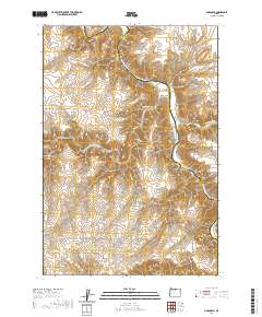
2020 Map of McDonald
USGS Topo · Published 2020About this map
The John Day River winds through the high desert of the Columbia Plateau, carving deep canyons that define the boundary between Sherman and Gilliam counties. The small settlement of McDonald sits near the river's edge, anchored by a network of local thoroughfares that recall the area's pioneer transit history, including McDonalds Ferry Ln and McDonald Ferry Rd. These roads provide access to the steep, dissected terrain where prominent landmarks like Starvation Point and the winding Grass Valley Canyon overlook the river valley.
Find a feature on this map
18 named features on this map. Tap any name to fly to it.
Don’t see what you’re looking for? This feature index may not catch every label — zoom into the map to look around manually.
Map Details
Editions of this 2020 McDonald Map
This is the sole edition of this map. No revisions or reprints were ever made.
Other maps of this area

1916 · Arlington
USGS Topo · 1:125,000

1916 · Condon
USGS Topo · 1:125,000

1953 · The Dalles
USGS Topo · 1:250,000

1956 · The Dalles
USGS Topo · 1:250,000

1957 · The Dalles
USGS Topo · 1:250,000

1957 · Wasco
USGS Topo · 1:62,500

1964 · Turner Butte
USGS Topo · 1:24,000

1964 · Mc Donald
USGS Topo · 1:24,000

1970 · Devils Backbone
USGS Topo · 1:24,000
1970 · Esau Canyon
USGS Topo · 1:24,000