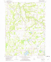
1981 Map of McDonald
USGS Topo · Published 1982About this map
The South Branch Black River and its tributary, Eastman Creek, cut through a landscape of fruit orchards and small rural hamlets in this corner of Van Buren County. Local movement is dictated by a rigid grid of country roads, including 16th Avenue and 46th Avenue, which link several historic crossroads such as Maple Grove Corners and Jericho Corners. The Chesapeake and Ohio railroad corridor anchors the southern half of the map, passing through the settlement of McDonald and near the waters of Von Auken Lake.
Find a feature on this map
47 named features on this map. Tap any name to fly to it.
Don’t see what you’re looking for? This feature index may not catch every label — zoom into the map to look around manually.
Map Details
Editions of this 1981 McDonald Map
This is the sole edition of this map. No revisions or reprints were ever made.
Other maps of this area

1927 · Hartford
USGS Topo · 1:62,500

1927 · Bangor
USGS Topo · 1:62,500

1927 · Benton Harbor
USGS Topo · 1:62,500

1927 · South Haven
USGS Topo · 1:62,500

1930 · South Haven
USGS Topo · 1:62,500

1930 · Benton Harbor
USGS Topo · 1:62,500

1931 · Bangor
USGS Topo · 1:62,500

1931 · Hartford
USGS Topo · 1:62,500

1943 · South Haven
USGS Topo · 1:62,500

1943 · Bangor
USGS Topo · 1:62,500