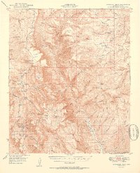
1950 Map of McFadden Peak
USGS Topo · Published 1950About this map
The Sierra Ancha Experimental Forest and the vast Tonto National Forest dominate this mid-century landscape in Gila County. The topography is defined by the high elevations of McFadden Pk and Aztec Pk, where specialized sites like the Parker Creek Experiment Sta were established for forestry research. The region's mining legacy is visible at the Lucky Strike Mine and Pueblo Mine near the center of the sheet, while hospitality is represented by the Aztec Lodge and Rose Cr Lodge nestled along the canyon drainages. A network of family-named ranching operations, including the Ellison Ranch, Murphy Ranch, and P B Ranch, suggests a long-standing agricultural and livestock presence. The intricate drainage system of Cherry Creek and its many tributaries like Workman Creek and Coon Creek carve deep through the mesas and flats.
Find a feature on this map
94 named features on this map. Tap any name to fly to it.
Don’t see what you’re looking for? This feature index may not catch every label — zoom into the map to look around manually.
Map Details
Editions of this 1950 McFadden Peak Map
2 editions found

Other maps of this area

1886 · Holbrook
USGS Topo · 1:250,000

1887 · Verde
USGS Topo · 1:250,000

1892 · Verde
USGS Topo · 1:250,000

1893 · Holbrook
USGS Topo · 1:250,000

1907 · Roosevelt
USGS Topo · 1:125,000

1909 · Four Peaks
USGS Topo · 1:125,000

1912 · Roosevelt
USGS Topo · 1:125,000

1922 · Chrysotile
USGS Topo · 1:125,000

1937 · Diamond Butte
USGS Topo · 1:48,000

1943 · Diamond Butte
USGS Topo · 1:62,500