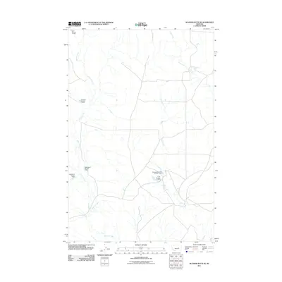
2011 Map of McGinnis Butte SE
USGS Topo · Published 2011About this map
McGinnis Creek and Indian Creek define the drainage patterns of this rural Rosebud County landscape. The area is characterized by a sophisticated network of small-scale water management infrastructure, evidenced by numerous named earthen structures such as the Glasscock Brothers Number 2 Dam and the L Galt Number 17 Dam. These features, alongside the NNN Ranch Number 1 Dam and NNN Ranch Number 2 Dam, suggest a long-standing reliance on local reservoirs to support livestock and ranching operations in this semi-arid environment. The meandering path of Short Creek cuts through the central terrain, connecting various private holdings that have shaped the local land-use history for generations. This map provides a clear look at the intersection of natural watercourses and the human-made modifications necessary for Montana ranching at the start of the twenty-first century.
Find a feature on this map
9 named features on this map. Tap any name to fly to it.
Don’t see what you’re looking for? This feature index may not catch every label — zoom into the map to look around manually.
Map Details
Editions of this 2011 McGinnis Butte SE Map
This is the sole edition of this map. No revisions or reprints were ever made.
Other maps of this area

1954 · Forsyth
USGS Topo · 1:250,000

1957 · Forsyth
USGS Topo · 1:250,000

1958 · Forsyth
USGS Topo · 1:250,000

1960 · Hagen Ranch
USGS Topo · 1:24,000

1960 · Yablonski Ranch
USGS Topo · 1:24,000

1960 · Black Sea Reservoir
USGS Topo · 1:24,000

1965 · Hole-In-The-Rock
USGS Topo · 1:24,000
1965 · Emma Butte
USGS Topo · 1:24,000
1965 · Mc Ginnis Butte
USGS Topo · 1:24,000
1965 · Mc Ginnis Butte SE
USGS Topo · 1:24,000