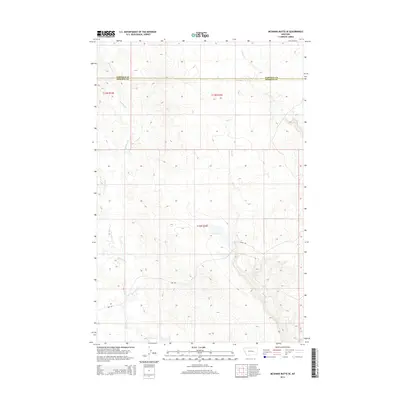
2014 Map of McGinnis Butte SE
USGS Topo · Published 2014About this map
McGinnis Cr winds through the heart of this landscape, carving a drainage system that defines the local topography along the border of Rosebud and Garfield counties. The terrain is characterized by the branching paths of Indian Cr and Short Cr, which intersect the high ground between the various drainage basins. Human presence is evidenced primarily by the long stretches of rural roads, including Shoup Rd and Nnn Rd, which navigate the rises and falls of the land. This 2014 survey documents the enduring pastoral character of this section of Montana, where the land is divided into the standard township and range system, including t13n r34e, t13n r35e, and t12n r35e. The map serves as a clear record of modern property boundaries and the delicate watercourses that have historically dictated movement and land use in this open country.
Find a feature on this map
9 named features on this map. Tap any name to fly to it.
Don’t see what you’re looking for? This feature index may not catch every label — zoom into the map to look around manually.
Map Details
Editions of this 2014 McGinnis Butte SE Map
This is the sole edition of this map. No revisions or reprints were ever made.
Other maps of this area

1954 · Forsyth
USGS Topo · 1:250,000

1957 · Forsyth
USGS Topo · 1:250,000

1958 · Forsyth
USGS Topo · 1:250,000
1960 · Hagen Ranch
USGS Topo · 1:24,000
1960 · Yablonski Ranch
USGS Topo · 1:24,000
1960 · Black Sea Reservoir
USGS Topo · 1:24,000
1965 · Hole-In-The-Rock
USGS Topo · 1:24,000
1965 · Emma Butte
USGS Topo · 1:24,000
1965 · Mc Ginnis Butte
USGS Topo · 1:24,000
1965 · Mc Ginnis Butte SE
USGS Topo · 1:24,000