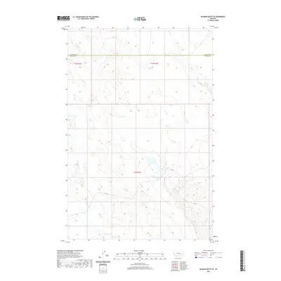
2020 Map of McGinnis Butte SE
USGS Topo · Published 2020About this map
The boundary between Garfield and Rosebud counties bisects this high plains landscape in eastern Montana. This 2020 map documents a terrain defined by its complex drainage systems, where McGinnis Creek and Little McGinnis Creek carve through the western portion of the quadrangle. To the east, the waters of Indian Creek and Short Creek shape the topography, illustrating the watershed patterns typical of this semi-arid region. Human infrastructure is minimal, represented largely by the path of Nnh Rd, which serves as a primary transit corridor across the southern townships. The map provides a clear look at the Public Land Survey System divisions, specifically T13N R34E, T13N R35E, and T12N R35E, making it an essential reference for understanding contemporary land use and topographic relief in this part of the state.
Find a feature on this map
9 named features on this map. Tap any name to fly to it.
Don’t see what you’re looking for? This feature index may not catch every label — zoom into the map to look around manually.
Map Details
Editions of this 2020 McGinnis Butte SE Map
This is the sole edition of this map. No revisions or reprints were ever made.
Other maps of this area

1954 · Forsyth
USGS Topo · 1:250,000

1957 · Forsyth
USGS Topo · 1:250,000

1958 · Forsyth
USGS Topo · 1:250,000

1960 · Hagen Ranch
USGS Topo · 1:24,000

1960 · Yablonski Ranch
USGS Topo · 1:24,000

1960 · Black Sea Reservoir
USGS Topo · 1:24,000

1965 · Hole-In-The-Rock
USGS Topo · 1:24,000
1965 · Emma Butte
USGS Topo · 1:24,000
1965 · Mc Ginnis Butte
USGS Topo · 1:24,000
1965 · Mc Ginnis Butte SE
USGS Topo · 1:24,000