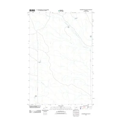
2011 Map of McGinnis Butte SW
USGS Topo · Published 2011About this map
Little McGinnis Creek winds across this section of Rosebud County, defining a landscape of drainage networks and water management in the eastern Montana plains. The topography is marked by a series of stock dams and reservoirs, including the L Galt Number 1 Dam, L Galt Number 3 Dam, and L Galt Number 7 Dam. These structures, alongside the US Number 25 Dam and Montana Number 14 Dam, indicate the critical role of water catchment for local ranching and land use. To the south, Big Breed Creek flows through the terrain, while the local road network is represented by routes such as Gumbo-Butte Rd and Edwards Rd, which provide access through this remote rural territory.
Find a feature on this map
9 named features on this map. Tap any name to fly to it.
Don’t see what you’re looking for? This feature index may not catch every label — zoom into the map to look around manually.
Map Details
Editions of this 2011 McGinnis Butte SW Map
This is the sole edition of this map. No revisions or reprints were ever made.
Other maps of this area

1954 · Forsyth
USGS Topo · 1:250,000

1957 · Forsyth
USGS Topo · 1:250,000

1958 · Forsyth
USGS Topo · 1:250,000

1960 · Yablonski Ranch
USGS Topo · 1:24,000

1960 · Black Sea Reservoir
USGS Topo · 1:24,000

1963 · Mc Williams Springs
USGS Topo · 1:24,000

1963 · Hecker Ranch
USGS Topo · 1:24,000

1963 · Regnal Coulee
USGS Topo · 1:24,000
1965 · Emma Butte
USGS Topo · 1:24,000
1965 · Mc Ginnis Butte
USGS Topo · 1:24,000