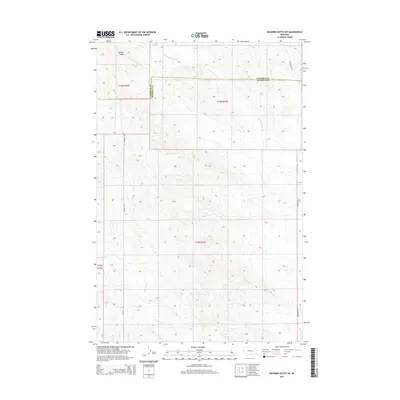
2014 Map of McGinnis Butte SW
USGS Topo · Published 2014About this map
The boundary between Garfield and Rosebud counties runs through this sparse section of central Montana, where the drainage patterns of Little McGinnis Cr and Big Breed Cr define the landscape. This 2014 survey documents a territory dominated by public land survey divisions, including townships t13n r33e, t13n r34e, and t12n r34e. The terrain is characterized by the prominent elevation of Gumbo Ridge in the northwest, overlooking a vast network of ephemeral coulees. Human presence is represented primarily by isolated gravel and dirt routes, most notably Sumatra N Rd and Ingomar Rd W, which provide essential access across the open range and agricultural allotments of the Great Plains.
Find a feature on this map
10 named features on this map. Tap any name to fly to it.
Don’t see what you’re looking for? This feature index may not catch every label — zoom into the map to look around manually.
Map Details
Editions of this 2014 McGinnis Butte SW Map
This is the sole edition of this map. No revisions or reprints were ever made.
Other maps of this area

1954 · Forsyth
USGS Topo · 1:250,000

1957 · Forsyth
USGS Topo · 1:250,000

1958 · Forsyth
USGS Topo · 1:250,000
1960 · Yablonski Ranch
USGS Topo · 1:24,000
1960 · Black Sea Reservoir
USGS Topo · 1:24,000
1963 · Mc Williams Springs
USGS Topo · 1:24,000
1963 · Hecker Ranch
USGS Topo · 1:24,000
1963 · Regnal Coulee
USGS Topo · 1:24,000
1965 · Emma Butte
USGS Topo · 1:24,000
1965 · Mc Ginnis Butte
USGS Topo · 1:24,000