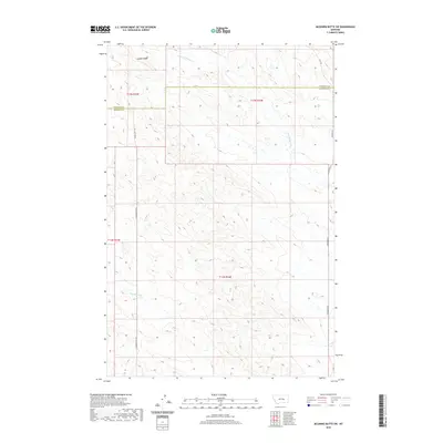
2020 Map of McGinnis Butte SW
USGS Topo · Published 2020About this map
Gumbo Ridge dominates this northern section of Rosebud County, Montana, providing a stark topographical backdrop to the expansive ranchlands near the Garfield County line. This area, largely defined by its drainage systems and primitive road networks, features the seasonal flows of Little McGinnis Cr and Big Breed Cr. The land is divided into vast rectangular sections by the Public Land Survey System, a pattern clearly visible in the straight trajectories of Gumbo Butte Rd and Ingomar Rd N. These dirt and gravel routes follow section lines through the breaks, connecting remote holdings in the late 2010s. The landscape reflects the characteristic high-plains geography of eastern Montana, where watercourses are the primary identifiers for local landmarks and navigation.
Find a feature on this map
12 named features on this map. Tap any name to fly to it.
Don’t see what you’re looking for? This feature index may not catch every label — zoom into the map to look around manually.
Map Details
Editions of this 2020 McGinnis Butte SW Map
This is the sole edition of this map. No revisions or reprints were ever made.
Other maps of this area

1954 · Forsyth
USGS Topo · 1:250,000

1957 · Forsyth
USGS Topo · 1:250,000

1958 · Forsyth
USGS Topo · 1:250,000

1960 · Yablonski Ranch
USGS Topo · 1:24,000

1960 · Black Sea Reservoir
USGS Topo · 1:24,000

1963 · Mc Williams Springs
USGS Topo · 1:24,000

1963 · Hecker Ranch
USGS Topo · 1:24,000

1963 · Regnal Coulee
USGS Topo · 1:24,000
1965 · Emma Butte
USGS Topo · 1:24,000
1965 · Mc Ginnis Butte
USGS Topo · 1:24,000