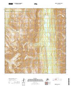
2019 Map of McGrath A-1 SW
USGS Topo · Published 2019About this map
The Terra Cotta Mountains dominate this high-altitude landscape in the interior of Alaska, where the northern foothills of the Alaska Range rise sharply from the valley floor. Running north-to-south through the eastern portion of the sheet, the South Fork Kuskokwim River serves as the primary hydrological artery, its braided channels carving through the glacial terrain. This 2019 survey documents a vast area devoid of roads or permanent settlements, instead highlighting the administrative divide between the Yukon-Koyukuk Census Area and the Bethel Census Area. The contour density illustrates the dramatic verticality of the peaks, providing a clear visualization of the natural barriers that have historically dictated travel and drainage patterns in this corner of the state.
Find a feature on this map
10 named features on this map. Tap any name to fly to it.
Don’t see what you’re looking for? This feature index may not catch every label — zoom into the map to look around manually.
Map Details
Editions of this 2019 McGrath A-1 SW Map
This is the sole edition of this map. No revisions or reprints were ever made.
Other maps of this area

1949 · McGrath
USGS Topo · 1:250,000

1950 · McGrath
USGS Topo · 1:250,000

1951 · Lime Hills
USGS Topo · 1:250,000

1958 · McGrath A-2
USGS Topo · 1:63,360

1958 · McGrath A-1
USGS Topo · 1:63,360
1958 · Lime Hills D-1
USGS Topo · 1:63,360
1958 · Lime Hills D-2
USGS Topo · 1:63,360

1958 · McGrath
USGS Topo · 1:250,000

1958 · Lime Hills
USGS Topo · 1:250,000
2017 · McGrath A-1 SE
USGS Topo · 1:25,000