
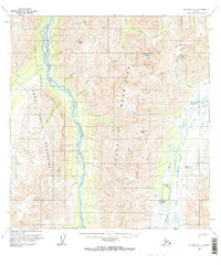
1958 Map of McGrath A-1
USGS Topo · Published 1963About this map
The Old Iditarod Trail provides a critical historical thread through this high-altitude landscape, tracing a path through the northeastern corner near Rainy Pass and Rainy Pass Lake. This 1958 survey captures a remote wilderness defined by the towering Terra Cotta Mountains and Teocalli Mountains, which channel the braided waters of the South Fork Kuskokwim River. The topography reveals the natural corridors of movement used by early travelers, such as Goodman Pass and Houston Pass, which bridge the divide between major drainage systems. Water features are abundant despite the high elevation, including Widgeon Lake, Hagen Lake, and the headwaters of the Happy River. This document preserves the exact alignment of the historic trail before modern changes altered the accessibility of the Alaskan interior.
Find a feature on this map
22 named features on this map. Tap any name to fly to it.
Don’t see what you’re looking for? This feature index may not catch every label — zoom into the map to look around manually.
Map Details
Editions of this 1958 McGrath A-1 Map
2 editions found
Other maps of this area

1949 · Tyonek
USGS Topo · 1:250,000

1949 · McGrath
USGS Topo · 1:250,000

1950 · McGrath
USGS Topo · 1:250,000

1950 · Talkeetna
USGS Topo · 1:250,000

1951 · Talkeetna
USGS Topo · 1:250,000

1951 · Tyonek
USGS Topo · 1:250,000

1951 · Lime Hills
USGS Topo · 1:250,000

1958 · Talkeetna A-6
USGS Topo · 1:63,360

1958 · Talkeetna B-6
USGS Topo · 1:63,360

1958 · McGrath B-1
USGS Topo · 1:63,360