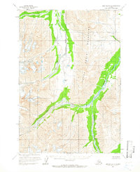
1958 Map of Lime Hills D-2
USGS Topo · Published 1966About this map
The Terra Cotta Mountains dominate this high-altitude interior landscape, defined by a network of glacial river systems and steep alpine passes. Mapping based on 1950s aerial photography shows the glacial runoff paths of the Post River and the Hartman River as they carve through the mountain range. This mid-century survey by the Geological Survey and the Bureau of Land Management captures the area before any established roads or trails were recorded, focusing instead on the hydrological and topographical reality of the wilderness. Key drainage features like Fish Creek and Boulder Creek are documented alongside notable transit points through the high peaks, specifically Strand Pass. The map provides an essential baseline for the region’s geography during a period of active aerial surveying in the Alaskan interior.
Find a feature on this map
6 named features on this map. Tap any name to fly to it.
Don’t see what you’re looking for? This feature index may not catch every label — zoom into the map to look around manually.
Map Details
Editions of this 1958 Lime Hills D-2 Map
2 editions found
Other maps of this area

1949 · McGrath
USGS Topo · 1:250,000

1950 · McGrath
USGS Topo · 1:250,000

1951 · Lime Hills
USGS Topo · 1:250,000

1958 · McGrath A-2
USGS Topo · 1:63,360

1958 · McGrath A-1
USGS Topo · 1:63,360

1958 · Lime Hills C-3
USGS Topo · 1:63,360
1958 · Lime Hills D-1
USGS Topo · 1:63,360

1958 · Lime Hills C-1
USGS Topo · 1:63,360

1958 · Lime Hills C-2
USGS Topo · 1:63,360

1958 · Lime Hills D-3
USGS Topo · 1:63,360