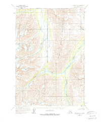
1958 Map of Lime Hills D-2
USGS Topo · Published 1978About this map
The Terra Cotta Mountains dominate this interior Alaskan landscape, creating a dramatic corridor for the glacial drainage systems that define the region. This 1958 field-annotated survey reveals a wilderness defined by its waterways, where the Post River and Hartman River converge amidst high-elevation terrain. The absence of roads or trails on this sheet, as noted in the 1977 minor revisions, underscores the isolation of the area during the mid-20th century. Notable topographical transitions occur at Strand Pass, providing a natural gateway between the drainage of Fish Creek and the larger river valleys. To the northeast, Boulder Creek carves through the slopes, illustrating the intricate network of tributaries that feed this part of the Lime Hills quadrangle.
Find a feature on this map
6 named features on this map. Tap any name to fly to it.
Don’t see what you’re looking for? This feature index may not catch every label — zoom into the map to look around manually.
Map Details
Editions of this 1958 Lime Hills D-2 Map
2 editions found
Other maps of this area

1949 · McGrath
USGS Topo · 1:250,000

1950 · McGrath
USGS Topo · 1:250,000

1951 · Lime Hills
USGS Topo · 1:250,000

1958 · McGrath A-2
USGS Topo · 1:63,360

1958 · McGrath A-1
USGS Topo · 1:63,360

1958 · Lime Hills C-3
USGS Topo · 1:63,360
1958 · Lime Hills D-1
USGS Topo · 1:63,360

1958 · Lime Hills C-1
USGS Topo · 1:63,360

1958 · Lime Hills C-2
USGS Topo · 1:63,360

1958 · Lime Hills D-3
USGS Topo · 1:63,360