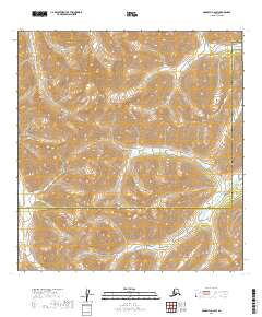
2019 Map of McGrath A-2 SW
USGS Topo · Published 2019About this map
The Alaska Range dominates the high-altitude terrain of this interior landscape, where steep contour lines and glacial drainages define the wilderness boundary between the Yukon-Koyukuk Census Area and the Bethel Census Area. This specific quadrangle captures a remote section of the Kuskokwim drainage basin, centered on the winding path of the Windy Fork Middle Fork Kuskokwim River as it cuts through the southwestern reaches of the range. The mapping reveals a complex network of high ridges and narrow valleys, illustrating the extreme topography that has historically dictated travel and access in this part of the Alaskan bush. Without roads or permanent settlements, the map documents the natural hydrology and land divisions that govern this unpopulated expanse, providing a precise topographic record of the area as it existed in 2019.
Find a feature on this map
3 named features on this map. Tap any name to fly to it.
Don’t see what you’re looking for? This feature index may not catch every label — zoom into the map to look around manually.
Map Details
Editions of this 2019 McGrath A-2 SW Map
This is the sole edition of this map. No revisions or reprints were ever made.
Other maps of this area

1949 · McGrath
USGS Topo · 1:250,000

1950 · McGrath
USGS Topo · 1:250,000

1951 · Lime Hills
USGS Topo · 1:250,000

1958 · McGrath A-2
USGS Topo · 1:63,360

1958 · McGrath A-3
USGS Topo · 1:63,360

1958 · Lime Hills D-3
USGS Topo · 1:63,360
1958 · Lime Hills D-2
USGS Topo · 1:63,360

1958 · McGrath
USGS Topo · 1:250,000

1958 · Lime Hills
USGS Topo · 1:250,000
2019 · Lime Hills D-3 NW
USGS Topo · 1:25,000