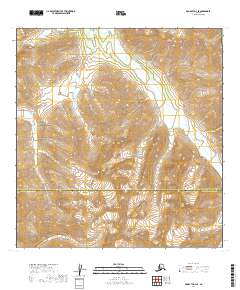
2019 Map of McGrath A-3 SE
USGS Topo · Published 2019About this map
The Alaska Range defines the high-altitude terrain of this interior region, where glacial drainages carve through a remote landscape of steep ridges and wide river valleys. The Windy Fork Middle Fork Kuskokwim River snakes through the northeast, characterized by the wide, braided gravel beds typical of sediment-heavy Alaskan waterways. To the west, the North Fork Big River marks another significant drainage system, both part of a vast watershed that remains largely unsettled. This 2019 survey documents the political geography of the area, specifically the boundary line between the Yukon-Koyukuk Census Area and the Bethel Census Area. The absence of roads or permanent structures underscores the wilderness character of the region, emphasizing the importance of natural landmarks for navigation in this stretch of the Alaska interior.
Find a feature on this map
10 named features on this map. Tap any name to fly to it.
Don’t see what you’re looking for? This feature index may not catch every label — zoom into the map to look around manually.
Map Details
Editions of this 2019 McGrath A-3 SE Map
This is the sole edition of this map. No revisions or reprints were ever made.
Other maps of this area

1949 · McGrath
USGS Topo · 1:250,000

1950 · McGrath
USGS Topo · 1:250,000

1951 · Lime Hills
USGS Topo · 1:250,000

1958 · McGrath A-2
USGS Topo · 1:63,360

1958 · McGrath A-3
USGS Topo · 1:63,360

1958 · Lime Hills D-3
USGS Topo · 1:63,360
1958 · Lime Hills D-4
USGS Topo · 1:63,360

1958 · McGrath
USGS Topo · 1:250,000

1958 · Lime Hills
USGS Topo · 1:250,000
2019 · Lime Hills D-3 NW
USGS Topo · 1:25,000