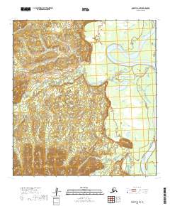
2019 Map of McGrath C-6 NW
USGS Topo · Published 2019About this map
Kuskokwim River defines the hydrological character of this portion of the Yukon-Koyukuk Census Area, where the massive waterway curves through a landscape marked by complex drainage networks. The meandering path of Beaver Cr and the presence of the Black River in the southern reaches illustrate a wilderness of braided streams and marshy lowlands typical of the Alaskan interior. This 2019 survey documents the natural state of the terrain before any significant modern development, focusing on the intricate topography of the low-lying river basins and the subtle elevation changes between the river valleys and the upland boundaries of T30N R35W and T29N R36W.
Find a feature on this map
9 named features on this map. Tap any name to fly to it.
Don’t see what you’re looking for? This feature index may not catch every label — zoom into the map to look around manually.
Map Details
Editions of this 2019 McGrath C-6 NW Map
This is the sole edition of this map. No revisions or reprints were ever made.
Other maps of this area

1949 · McGrath
USGS Topo · 1:250,000

1950 · McGrath
USGS Topo · 1:250,000

1951 · Iditarod
USGS Topo · 1:250,000

1954 · McGrath D-6
USGS Topo · 1:63,360

1954 · McGrath C-6
USGS Topo · 1:63,360
1954 · Iditarod D-1
USGS Topo · 1:63,360
1955 · Iditarod D-1
USGS Topo · 1:63,360
1956 · Iditarod C-1
USGS Topo · 1:63,360

1956 · Iditarod
USGS Topo · 1:250,000

1958 · McGrath
USGS Topo · 1:250,000