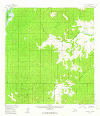
1956 Map of Iditarod C-1
USGS Topo · Published 1962About this map
The Takotna River winds through the northwestern corner of this 1950s interior Alaska landscape, defining a remote terrain of low-lying wetlands and forested ridges. This survey illustrates a wilderness devoid of mapped roads or trails, emphasizing the primary role of natural watercourses like Beaver Creek and the Black River for navigation and orientation. High points are identified by triangulation stations, including VABM La 1447 and VABM Black 1516, which provide precise elevation data in a territory still largely unmapped by ground-level field checking at the time of publication. The lack of settlements or permanent structures highlights the isolation of this portion of the Yukon-Koyukuk region during the mid-century era, as surveying efforts relied heavily on aerial photography and photogrammetric methods to document the complex drainage patterns and relief.
Find a feature on this map
6 named features on this map. Tap any name to fly to it.
Don’t see what you’re looking for? This feature index may not catch every label — zoom into the map to look around manually.
Map Details
Editions of this 1956 Iditarod C-1 Map
2 editions found
Other maps of this area

1949 · McGrath
USGS Topo · 1:250,000

1950 · McGrath
USGS Topo · 1:250,000

1951 · Iditarod
USGS Topo · 1:250,000

1954 · McGrath D-6
USGS Topo · 1:63,360

1954 · Iditarod B-1
USGS Topo · 1:63,360

1954 · McGrath B-6
USGS Topo · 1:63,360

1954 · McGrath C-6
USGS Topo · 1:63,360

1954 · Iditarod B-2
USGS Topo · 1:63,360

1954 · Iditarod C-2
USGS Topo · 1:63,360

1954 · Iditarod D-2
USGS Topo · 1:63,360