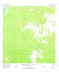
1956 Map of Iditarod C-1
USGS Topo · Published 1973About this map
The Takotna River winds through the northwestern corner of this interior landscape, marking a transition between the low-lying wetlands and the rising elevations to the south. Recorded in the mid-1950s, this survey highlights an area dominated by intricate hydrological networks, including the meandering paths of Beaver Creek and Big Creek. The southern portion of the quadrangle is defined by more prominent relief, specifically Black Mountain and the survey stations VABM Black 1515 and VABM Lin 1447, which provided the critical horizontal and vertical control points for mapping this roadless terrain. The presence of the Black River in the south further illustrates the complex drainage patterns of the region. This 1:63,360 scale study is characterized by its lack of established human infrastructure, focusing instead on the natural topography as predetermined by the Bureau of Land Management for the Seward Meridian.
Find a feature on this map
7 named features on this map. Tap any name to fly to it.
Don’t see what you’re looking for? This feature index may not catch every label — zoom into the map to look around manually.
Map Details
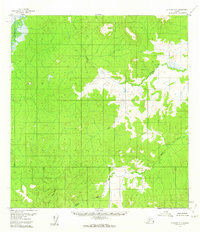
Editions of this 1956 Iditarod C-1 Map
2 editions found
Other maps of this area

1949 · McGrath
USGS Topo · 1:250,000

1950 · McGrath
USGS Topo · 1:250,000

1951 · Iditarod
USGS Topo · 1:250,000

1954 · McGrath D-6
USGS Topo · 1:63,360

1954 · Iditarod B-1
USGS Topo · 1:63,360

1954 · McGrath B-6
USGS Topo · 1:63,360

1954 · McGrath C-6
USGS Topo · 1:63,360

1954 · Iditarod B-2
USGS Topo · 1:63,360

1954 · Iditarod C-2
USGS Topo · 1:63,360

1954 · Iditarod D-2
USGS Topo · 1:63,360