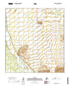
2019 Map of McGrath D-2 SW
USGS Topo · Published 2019About this map
The South Fork Kuskokwim River defines the western edge of this Alaskan landscape, part of a complex watershed where the Salmon River and Big Salmon Fork carve through the interior wilderness. This 2019 survey captures the area within the Yukon-Koyukuk Census Area, illustrating the intricate braided river systems and drainage patterns typical of the McGrath region. The map serves as a vital record of the shifting hydrological features and topographical contours between the t32n r25w and t31n r24w township boundaries. Because this area is largely composed of government-managed lands and potential private allotments, the map provides essential detail for navigating the river corridors that historically served as the primary transit routes through this portion of the Alaska interior.
Find a feature on this map
7 named features on this map. Tap any name to fly to it.
Don’t see what you’re looking for? This feature index may not catch every label — zoom into the map to look around manually.
Map Details
Editions of this 2019 McGrath D-2 SW Map
This is the sole edition of this map. No revisions or reprints were ever made.
Other maps of this area

1949 · McGrath
USGS Topo · 1:250,000

1950 · McGrath
USGS Topo · 1:250,000

1954 · McGrath D-3
USGS Topo · 1:63,360

1954 · McGrath C-3
USGS Topo · 1:63,360

1958 · McGrath D-2
USGS Topo · 1:63,360

1958 · McGrath C-2
USGS Topo · 1:63,360

1958 · McGrath
USGS Topo · 1:250,000
2019 · McGrath D-2 SE
USGS Topo · 1:25,000
2019 · McGrath D-2 NE
USGS Topo · 1:25,000
2019 · McGrath C-2 NE
USGS Topo · 1:25,000