
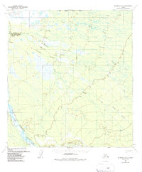
1958 Map of McGrath D-2
USGS Topo · Published 1963About this map
The South Fork Kuskokwim River anchors the southwestern corner of this interior Alaskan landscape, which was primarily unmapped on the ground when these 1950s aerial surveys were conducted. A seasonal transportation network is indicated by the Winter Trail, which cuts across the marshy lowlands north of the Big Salmon Fork. This region is defined by a dense network of braided waterways and glacial runoff, where the Tonzona River and its various tributaries, including the South Fork Tonzona River and Pinkston Fork, create a complex drainage pattern. The absence of permanent settlements and the reliance on winter-only routes reflect the formidable challenges of navigating this terrain before more modern infrastructure. Other notable water features include the aptly named Deepbank Creek, Clear Fork, and No Creek.
Find a feature on this map
10 named features on this map. Tap any name to fly to it.
Don’t see what you’re looking for? This feature index may not catch every label — zoom into the map to look around manually.
Map Details
Editions of this 1958 McGrath D-2 Map
2 editions found
Other maps of this area

1949 · McGrath
USGS Topo · 1:250,000

1950 · Medfra
USGS Topo · 1:250,000

1950 · McGrath
USGS Topo · 1:250,000

1954 · McGrath D-3
USGS Topo · 1:63,360

1954 · McGrath C-3
USGS Topo · 1:63,360

1954 · Medfra A-3
USGS Topo · 1:63,360

1958 · Medfra A-2
USGS Topo · 1:63,360

1958 · McGrath C-1
USGS Topo · 1:63,360

1958 · McGrath C-2
USGS Topo · 1:63,360

1958 · Medfra A-1
USGS Topo · 1:63,360