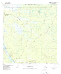
1958 Map of McGrath D-2
USGS Topo · Published 1987About this map
The South Fork Kuskokwim River and its complex braided tributaries dominate this 1950s interior landscape, showing the drainage patterns of the Yukon-Koyukuk region before modern development. A persistent Winter Trail cuts across the northern reaches, crossing the Tonzona River and several minor streams, serving as a vital overland link in a region defined by its seasonal mobility. The survey details the convergence of the Big Salmon Fork Kuskokwim River and numerous secondary waterways like Deepbank Creek and Clear Fork Tonzona River. These geographic features follow the North Boundary Seward Meridian, providing a look at the surveyed lines used to organize this remote territory for the Bureau of Land Management.
Find a feature on this map
10 named features on this map. Tap any name to fly to it.
Don’t see what you’re looking for? This feature index may not catch every label — zoom into the map to look around manually.
Map Details
Editions of this 1958 McGrath D-2 Map
2 editions found
Other maps of this area

1949 · McGrath
USGS Topo · 1:250,000

1950 · Medfra
USGS Topo · 1:250,000

1950 · McGrath
USGS Topo · 1:250,000

1954 · McGrath D-3
USGS Topo · 1:63,360

1954 · McGrath C-3
USGS Topo · 1:63,360

1954 · Medfra A-3
USGS Topo · 1:63,360

1958 · McGrath D-2
USGS Topo · 1:63,360

1958 · Medfra A-2
USGS Topo · 1:63,360

1958 · McGrath C-1
USGS Topo · 1:63,360

1958 · McGrath C-2
USGS Topo · 1:63,360