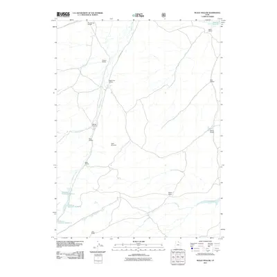
2011 Map of McKay Hollow
USGS Topo · Published 2011About this map
Neponset Reservoir and Crane Reservoir anchor this 2011 topographic study of the high desert terrain in Rich County. The landscape is defined by a complex system of water management and seasonal drainages, visible through the series of impoundments known as Saleratus Reservoir Number 1, Saleratus Reservoir Number 2, and Saleratus Reservoir Number 3. These features, along with names like Beer Hollow and Chicken Hollow, reflect the ranching heritage of the region, where water sources were critical for livestock. The terrain transitions from the prominent flats of Table Mountain to the high elevations of McKay Ridge and Lake Ridge. Navigational infrastructure is minimal, centered primarily on Main Ranch Way, which provides access through the various canyons and hollows that carve this arid landscape.
Find a feature on this map
24 named features on this map. Tap any name to fly to it.
Don’t see what you’re looking for? This feature index may not catch every label — zoom into the map to look around manually.
Map Details
Editions of this 2011 McKay Hollow Map
This is the sole edition of this map. No revisions or reprints were ever made.
Other maps of this area

1954 · Ogden
USGS Topo · 1:250,000

1958 · Ogden
USGS Topo · 1:250,000

1960 · Ogden
USGS Topo · 1:250,000

1964 · Francis Canyon
USGS Topo · 1:24,000

1968 · Wahsatch
USGS Topo · 1:24,000

1968 · Shearing Corral
USGS Topo · 1:24,000

1968 · Mc Kay Hollow
USGS Topo · 1:24,000

1968 · Neponset Reservoir NE
USGS Topo · 1:24,000

1968 · Meachum Ridge
USGS Topo · 1:24,000

1968 · Peck Canyon
USGS Topo · 1:24,000