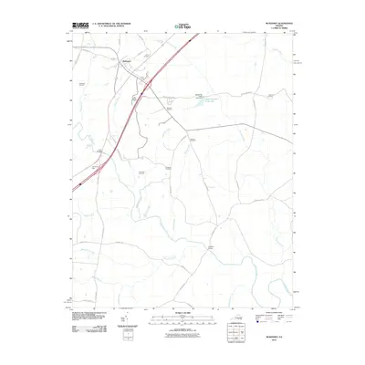
2010 Map of McKenney
USGS Topo · Published 2010About this map
McKenney serves as the primary hub in this southern Virginia landscape, situated where the Interstate 85 corridor intersects historical local routes like Old Stage Rd and Depot Rd. The surrounding terrain is defined by an intricate network of waterways, including the winding Nottoway River and its many tributaries such as Buckskin Creek, Sappony Creek, and Waqua Creek. Numerous family-named burial grounds, such as Asbury Cemetery, Abernathy Cemetery, and Williams Cemetery, are scattered across the quadrangle, indicating a deep history of rural settlement and local genealogy. The presence of Mckenney Hunt Club Lake and its associated Mckenney Hunt Club Dam reflects the area's recreational land use. Significant infrastructure like Long Bridge and Cutbank Bridge facilitate movement across the diverse stream system that feeds into the river valley.
Find a feature on this map
44 named features on this map. Tap any name to fly to it.
Don’t see what you’re looking for? This feature index may not catch every label — zoom into the map to look around manually.
Map Details
Editions of this 2010 McKenney Map
This is the sole edition of this map. No revisions or reprints were ever made.
Other maps of this area

1897 · Amelia
USGS Topo · 1:125,000

1918 · Lawrenceville
USGS Topo · 1:62,500

1919 · Mc Kenney
USGS Topo · 1:48,000

1920 · Lawrenceville
USGS Topo · 1:48,000

1921 · Mc Kenney
USGS Topo · 1:62,500

1921 · Lawrenceville
USGS Topo · 1:62,500

1942 · Lawrenceville
USGS Topo · 1:62,500

1943 · Mc Kenney
USGS Topo · 1:62,500

1943 · De Witt
USGS Topo · 1:24,000

1943 · Dinwiddie
USGS Topo · 1:24,000