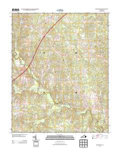
2013 Map of McKenney
USGS Topo · Published 2013About this map
McKenney serves as the primary hub of this Dinwiddie County landscape, where the local street grid including Railroad St and Factory St points toward the area's historical transition from rail-side industry to a modern rural community. The terrain is defined by a dense network of waterways feeding into the Nottoway River at the southern boundary, with Sturgeon Cr and Buckskin Cr carving through the countryside. This 2013 survey illustrates the persistence of old transportation corridors, such as Old Stage Rd, which parallel newer infrastructure. Notable local landmarks like the Mckenney Hunt Club Lake and small settlements at Long Bridge and Cutbank Bridge reflect a landscape shaped by both recreation and the agricultural requirements of Southside Virginia.
Find a feature on this map
50 named features on this map. Tap any name to fly to it.
Don’t see what you’re looking for? This feature index may not catch every label — zoom into the map to look around manually.
Map Details
Editions of this 2013 McKenney Map
This is the sole edition of this map. No revisions or reprints were ever made.
Other maps of this area

1897 · Amelia
USGS Topo · 1:125,000

1918 · Lawrenceville
USGS Topo · 1:62,500

1919 · Mc Kenney
USGS Topo · 1:48,000

1920 · Lawrenceville
USGS Topo · 1:48,000

1921 · Mc Kenney
USGS Topo · 1:62,500

1921 · Lawrenceville
USGS Topo · 1:62,500

1942 · Lawrenceville
USGS Topo · 1:62,500

1943 · Mc Kenney
USGS Topo · 1:62,500

1943 · De Witt
USGS Topo · 1:24,000

1943 · Dinwiddie
USGS Topo · 1:24,000