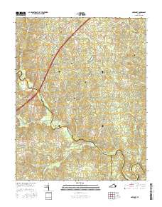
2016 Map of McKenney
USGS Topo · Published 2016About this map
McKenney serves as the primary hub for this Dinwiddie County landscape, situated where Boydton Plank Rd and Rives Ave intersect. The settlement pattern is defined by family-named landmarks and ancestral burial grounds that offer significant genealogical value, including Abernathy Cem, Fitzgerald Cem, and Williams Cem. The southern reach of the quadrangle is defined by the winding course of the Nottoway River, which forms the boundary with Brunswick and Greensville counties.
Find a feature on this map
55 named features on this map. Tap any name to fly to it.
Don’t see what you’re looking for? This feature index may not catch every label — zoom into the map to look around manually.
Map Details
Editions of this 2016 McKenney Map
This is the sole edition of this map. No revisions or reprints were ever made.
Other maps of this area

1897 · Amelia
USGS Topo · 1:125,000

1918 · Lawrenceville
USGS Topo · 1:62,500

1919 · Mc Kenney
USGS Topo · 1:48,000

1920 · Lawrenceville
USGS Topo · 1:48,000

1921 · Mc Kenney
USGS Topo · 1:62,500

1921 · Lawrenceville
USGS Topo · 1:62,500

1942 · Lawrenceville
USGS Topo · 1:62,500

1943 · Mc Kenney
USGS Topo · 1:62,500

1943 · De Witt
USGS Topo · 1:24,000

1943 · Dinwiddie
USGS Topo · 1:24,000