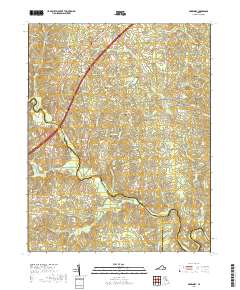
2019 Map of McKenney
USGS Topo · Published 2019About this map
The town of McKenney serves as the focal point of this modern topographic survey, positioned at the intersection of the historic Boydton Plank Rd and the Railroad St corridor. The landscape is defined by the winding course of the Nottoway River to the south and the Sturgeon Cr and Buckskin Cr drainages. A high density of family and community burial grounds, such as Asbury Cem, Abernathy Cem, and the Williams and Epps Cem, indicates a deeply rooted rural population across the Dinwiddie and Brunswick county lines.
Find a feature on this map
58 named features on this map. Tap any name to fly to it.
Don’t see what you’re looking for? This feature index may not catch every label — zoom into the map to look around manually.
Map Details
Editions of this 2019 McKenney Map
This is the sole edition of this map. No revisions or reprints were ever made.
Other maps of this area

1897 · Amelia
USGS Topo · 1:125,000

1918 · Lawrenceville
USGS Topo · 1:62,500

1919 · Mc Kenney
USGS Topo · 1:48,000

1920 · Lawrenceville
USGS Topo · 1:48,000

1921 · Mc Kenney
USGS Topo · 1:62,500

1921 · Lawrenceville
USGS Topo · 1:62,500

1942 · Lawrenceville
USGS Topo · 1:62,500

1943 · Mc Kenney
USGS Topo · 1:62,500

1943 · De Witt
USGS Topo · 1:24,000

1943 · Dinwiddie
USGS Topo · 1:24,000