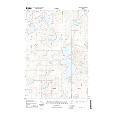
2015 Map of McKenzie Lake
USGS Topo · Published 2015About this map
Glacial lakes dominate the landscape of the Wisconsin Northwoods along the border of Burnett and Washburn counties. The interconnected chain of Middle McKenzie Lake, Lower McKenzie Lake, and McKenzie Lake serves as the primary geographical focus, surrounded by a dense network of smaller bodies of water like Nicaboyne Lake and Benoit Lake. Human development is concentrated around these shores, where local roads such as McKenzie Rd and Co Hwy H provide access to seasonal and permanent residences. Local history and community markers are present in the form of the Sacred Hearts Cem and the Alpha Hotel, situated near Crescent Lake. This survey illustrates a modern recreation-based economy where the wilder terrain of the t40n r14w township is defined more by its hydrography and forest roads than by industrial centers.
Find a feature on this map
109 named features on this map. Tap any name to fly to it.
Don’t see what you’re looking for? This feature index may not catch every label — zoom into the map to look around manually.
Map Details
Editions of this 2015 McKenzie Lake Map
This is the sole edition of this map. No revisions or reprints were ever made.
Other maps of this area

1947 · Minong
USGS Topo · 1:48,000

1948 · Spooner
USGS Topo · 1:48,000

1949 · Hertel
USGS Topo · 1:48,000

1949 · Minong
USGS Topo · 1:48,000

1949 · Webb Lake
USGS Topo · 1:48,000

1949 · Spooner
USGS Topo · 1:48,000

1953 · Ashland
USGS Topo · 1:250,000

1953 · Duluth
USGS Topo · 1:250,000

1953 · Rice Lake
USGS Topo · 1:250,000

1953 · Stillwater
USGS Topo · 1:250,000