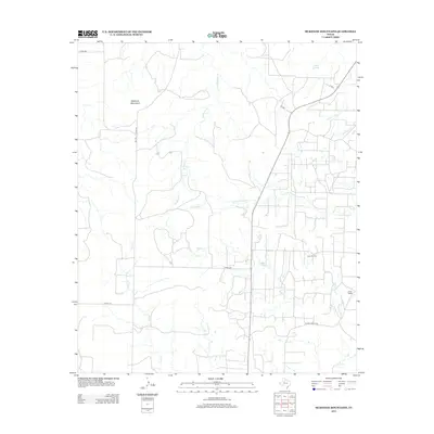
2012 Map of McKenzie Mountains
USGS Topo · Published 2012About this map
The McKenzie Mountains rise above a landscape defined by an extensive network of ephemeral waterways and modern petroleum infrastructure in Scurry County. The dominant industrial feature is the Fuller Oil Field, which is supported by a dense grid of local roads and unimproved tracks. The presence of Fuller Ranch and the associated Fuller E Ranch Rd points to a dual-use economy where ranching and energy extraction coexist. A series of drainage systems, including Rough Cr, Little Rough Cr, and Ennis Cr, cut through the terrain, originating from the higher elevations of the mountains. Elkins Springs serves as a notable hydrologic landmark in the northern portion of the quadrangle, where the terrain transitions into more defined creek beds like Cooper Cr. This 2012 survey provides a precise layout of the county roads and ranch boundaries that facilitate access across this portion of the Texas plains.
Find a feature on this map
17 named features on this map. Tap any name to fly to it.
Don’t see what you’re looking for? This feature index may not catch every label — zoom into the map to look around manually.
Map Details
Editions of this 2012 McKenzie Mountains Map
This is the sole edition of this map. No revisions or reprints were ever made.
Other maps of this area
1954 · Lloyd Mountain
USGS Topo · 1:24,000
1954 · Dermott
USGS Topo · 1:24,000
1954 · Brand
USGS Topo · 1:24,000
1954 · Lubbock
USGS Topo · 1:250,000
1954 · Big Spring
USGS Topo · 1:250,000
1958 · Big Spring
USGS Topo · 1:250,000
1969 · Justiceburg SE
USGS Topo · 1:24,000
1969 · Maverick Creek
USGS Topo · 1:24,000
1969 · Cooper Mountain
USGS Topo · 1:24,000
1969 · Flat Top Mountain
USGS Topo · 1:24,000