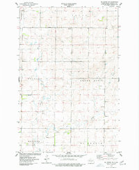
1975 Map of McKenzie NW
USGS Topo · Published 1977About this map
Sibley Butte and the surrounding plains of Burleigh County are defined by a high concentration of agrarian fence lines and field boundaries, meticulously recorded from 1974 aerial photography. The landscape is bisected by the winding Apple Creek, which receives flow from its West Branch and East Branch tributaries. This mid-1970s survey illustrates a region organized by township boundaries, including portions of Cromwell, Trygg, Menoken, and Mckenzie. Local civic life is anchored by the Townhall located near the eastern edge of Frances, while the small Sibley Cem serves as a genealogical marker for the area's early residents. The prevalence of numerous Gravel Pits suggests an active local industry in extraction and road maintenance during this period.
Find a feature on this map
14 named features on this map. Tap any name to fly to it.
Don’t see what you’re looking for? This feature index may not catch every label — zoom into the map to look around manually.
Map Details
Editions of this 1975 McKenzie NW Map
This is the sole edition of this map. No revisions or reprints were ever made.
Other maps of this area

1907 · Bismarck
USGS Topo · 1:125,000

1951 · Menoken
USGS Topo · 1:62,500

1951 · McKenzie
USGS Topo · 1:62,500

1954 · Bismarck
USGS Topo · 1:250,000

1954 · McClusky
USGS Topo · 1:250,000

1958 · Bismarck
USGS Topo · 1:250,000

1958 · McClusky
USGS Topo · 1:250,000

1975 · McKenzie
USGS Topo · 1:24,000

1975 · Sibley Butte
USGS Topo · 1:24,000

1975 · Sterling
USGS Topo · 1:24,000