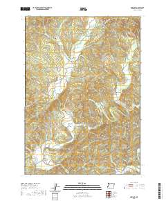
2020 Map of McKinley
USGS Topo · Published 2020About this map
The North Fork Coquille River carves through the interior of Coos County, defining the settlement patterns of Fairview and McKinley. This recent topographic study documents a landscape where historical infrastructure remains vital, from the winding path of the Coos Bay Wagon Rd to several named river crossings including Fairview Bridge, Hervey Bridge, and the Lone Pine Bridge. The map is particularly useful for genealogical research, identifying small family and community burial sites like Morris-Baker Cem, Fairview Cem, and Fox Bridge Cem situated near the watercourses. Elevated terrain such as Blue Ridge and Rink Peak overlooks the fertile Burton Prairie and the transition into Lee Valley, while numerous tributaries like Middle Cr and Yankee Run illustrate the complex drainage of the Oregon Coast Range foothills.
Find a feature on this map
61 named features on this map. Tap any name to fly to it.
Don’t see what you’re looking for? This feature index may not catch every label — zoom into the map to look around manually.
Map Details
Editions of this 2020 McKinley Map
This is the sole edition of this map. No revisions or reprints were ever made.
Other maps of this area

1896 · Coos Bay
USGS Topo · 1:125,000

1898 · Coos Bay
USGS Topo · 1:125,000

1900 · Coos Bay
USGS Topo · 1:125,000

1928 · Sitkum
USGS Topo · 1:125,000

1942 · Coquille
USGS Topo · 1:62,500

1942 · Coos Bay
USGS Topo · 1:62,500

1945 · Coquille
USGS Topo · 1:62,500

1945 · Coos Bay
USGS Topo · 1:62,500

1954 · Coos Bay
USGS Topo · 1:250,000

1955 · Ivers Peak
USGS Topo · 1:62,500