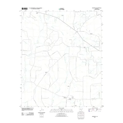
2011 Map of McKinney
USGS Topo · Published 2011About this map
L'Aigle Creek and its many tributaries, including Steepbank L'Aigle Creek and Irish Bill Creek, define the drainage patterns of this rural Arkansas landscape. The settlement geography is marked by small communities like Orlando, Weeks, and McKinney, which are linked by a network of local routes such as Bradley Road 15 and Bradley Road 16.
Find a feature on this map
67 named features on this map. Tap any name to fly to it.
Don’t see what you’re looking for? This feature index may not catch every label — zoom into the map to look around manually.
Map Details
Editions of this 2011 McKinney Map
This is the sole edition of this map. No revisions or reprints were ever made.
Other maps of this area

1953 · El Dorado
USGS Topo · 1:250,000

1957 · El Dorado
USGS Topo · 1:250,000

1958 · El Dorado
USGS Topo · 1:250,000

1960 · El Dorado
USGS Topo · 1:250,000

1966 · Kingsland
USGS Topo · 1:24,000

1970 · New Edinburg
USGS Topo · 1:24,000

1970 · Herbine
USGS Topo · 1:24,000
1973 · Warren
USGS Topo · 1:24,000
1973 · Mc Kinney
USGS Topo · 1:24,000
1973 · Farmville
USGS Topo · 1:24,000