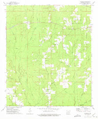
1973 Map of Farmville
USGS Topo · Published 1975About this map
L'Aigle Creek and its many tributaries, including Steepbank Creek and Beech Creek, define the landscape of northern Bradley County. In the early 1970s, the area's rural character was anchored by several small communities and their spiritual centers, such as Farmville with its Farmville Ch and Pleasant Grove Ch. The influence of the timber or extraction industry is evident in the numerous Gravel Pits and the Banks Lookout Tower positioned for forest surveillance. Transportation patterns show a mix of active and former corridors, from the operational Chicago Rock Island and Pacific railroad to an Old Railroad Grade further east. Local history and genealogy are well-represented by rural landmarks like Parnell Cem, Parker Cem, and Oaklawn Ch, providing a detailed look at the settlement patterns of this timber-rich region of Arkansas.
Find a feature on this map
33 named features on this map. Tap any name to fly to it.
Don’t see what you’re looking for? This feature index may not catch every label — zoom into the map to look around manually.
Map Details
Editions of this 1973 Farmville Map
2 editions found
Other maps of this area

1934 · Ingalls
USGS Topo · 1:48,000

1934 · Moro Bay
USGS Topo · 1:62,500

1937 · Ingalls
USGS Topo · 1:62,500

1938 · Moro Bay
USGS Topo · 1:62,500

1939 · Moro Bay
USGS Topo · 1:62,500

1939 · Ingalls
USGS Topo · 1:62,500

1953 · El Dorado
USGS Topo · 1:250,000

1957 · El Dorado
USGS Topo · 1:250,000

1958 · El Dorado
USGS Topo · 1:250,000

1960 · El Dorado
USGS Topo · 1:250,000