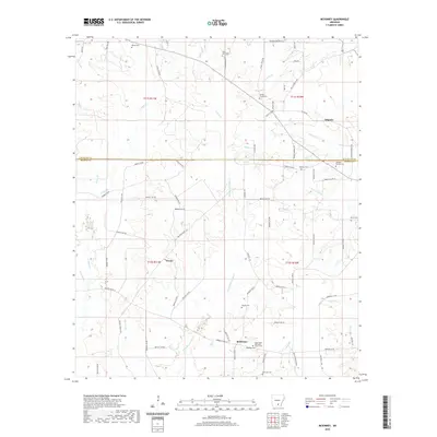
2020 Map of McKinney
USGS Topo · Published 2020About this map
Orlando and McKinney anchor this rural landscape in south-central Arkansas, where the border of Cleveland and Bradley counties is defined by a network of creeks and timberland. The map reveals a high concentration of small family and community burial grounds, such as Bethel Cem, Moseley Cem, and the Good Hope Methodist Church Cem, suggesting a long-established pattern of dispersed homesteading. The terrain is intricately carved by numerous watercourses, including the Steepbank L'Aigle Cr and Hollis Cr, which dictate the winding paths of local connectors like Bradley Road 16. The settlement at Weeks and the various rural roads illustrate the transition from early 20th-century agriculture to the more modern forest-management roads seen today.
Find a feature on this map
81 named features on this map. Tap any name to fly to it.
Don’t see what you’re looking for? This feature index may not catch every label — zoom into the map to look around manually.
Map Details
Editions of this 2020 McKinney Map
This is the sole edition of this map. No revisions or reprints were ever made.
Other maps of this area

1953 · El Dorado
USGS Topo · 1:250,000

1957 · El Dorado
USGS Topo · 1:250,000

1958 · El Dorado
USGS Topo · 1:250,000

1960 · El Dorado
USGS Topo · 1:250,000

1966 · Kingsland
USGS Topo · 1:24,000

1970 · New Edinburg
USGS Topo · 1:24,000

1970 · Herbine
USGS Topo · 1:24,000
1973 · Warren
USGS Topo · 1:24,000
1973 · Mc Kinney
USGS Topo · 1:24,000
1973 · Farmville
USGS Topo · 1:24,000