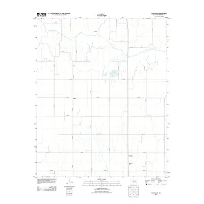
2012 Map of McKnight
USGS Topo · Published 2012About this map
The Salt Fork Red River meanders across the northern section of this landscape, defining the hydrology of a region where water management is central to the local economy. The presence of the Mary Kromer Reservoir and the Oklahoma State Fish and Wildlife Reservoir indicates a focus on conservation and water storage within Harmon County. The settlement of McKnight and the nearby McKnight Cem serve as focal points for local history and genealogy, anchored by a grid of rural roads such as R R RD and N 1700 RD. The terrain is further etched by seasonal drainage including Horse Cr, E Fork Sandy Cr, and Bitter Cr, which feed into the larger river system. This rural Oklahoma landscape, featuring the small settlement of Sandy, showcases the typical section-line road development characteristic of the Great Plains.
Find a feature on this map
31 named features on this map. Tap any name to fly to it.
Don’t see what you’re looking for? This feature index may not catch every label — zoom into the map to look around manually.
Map Details
Editions of this 2012 McKnight Map
This is the sole edition of this map. No revisions or reprints were ever made.
Other maps of this area

1954 · Plainview
USGS Topo · 1:250,000

1955 · Lawton
USGS Topo · 1:250,000

1958 · Plainview
USGS Topo · 1:250,000

1959 · Shinnery Creek
USGS Topo · 1:24,000

1960 · Loco
USGS Topo · 1:62,500

1961 · Hollis
USGS Topo · 1:62,500

1964 · Dodson
USGS Topo · 1:24,000
1971 · Madge
USGS Topo · 1:24,000

1971 · Vinson
USGS Topo · 1:24,000
1971 · Mc Knight
USGS Topo · 1:24,000