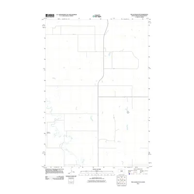
2011 Map of McLaughlin NE
USGS Topo · Published 2011About this map
Oak Creek meanders through this portion of the Standing Rock Reservation area, defining the drainage patterns across a landscape marked by agricultural water management. The terrain is characterized by the presence of small-scale infrastructure like the Gustave Aman Dam and the TW Lyman Dam, which reflect the localized efforts to manage water resources in the plains of South Dakota. In 2011, this area shows a sparse network of section-line roads, including 98th St, providing access across the open country. The distribution of these water features and road paths suggests a pastoral environment where cattle grazing and small-scale farming depend on these vital water catchments.
Find a feature on this map
4 named features on this map. Tap any name to fly to it.
Don’t see what you’re looking for? This feature index may not catch every label — zoom into the map to look around manually.
Map Details
Editions of this 2011 McLaughlin NE Map
This is the sole edition of this map. No revisions or reprints were ever made.
Other maps of this area

1953 · McIntosh
USGS Topo · 1:250,000

1954 · Bismarck
USGS Topo · 1:250,000

1958 · Bismarck
USGS Topo · 1:250,000

1958 · McIntosh
USGS Topo · 1:250,000

1966 · McLaughlin
USGS Topo · 1:24,000

1966 · McLaughlin NE
USGS Topo · 1:24,000

1966 · Mahto
USGS Topo · 1:24,000

1966 · Mahto NW
USGS Topo · 1:24,000

1968 · Fort Yates
USGS Topo · 1:24,000
1971 · Selfridge SE
USGS Topo · 1:24,000