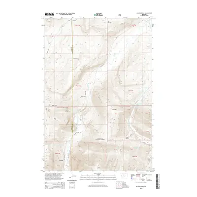
2014 Map of McLeod Basin
USGS Topo · Published 2014About this map
Contact sits at the southern edge of this 2014 survey, marking a small settlement at the confluence of Contact Cr and the Boulder River. This high-altitude landscape is defined by the sharp transition from the open drainages of the McLeod Basin into the protected wilderness of the Gallatin National Forest. The map documents a complex network of forest roads and trails, including Main Boulder Rd and W Boulder Rd, which provide access to the area's prominent peaks like Baker Mtn and Contact Mtn. A notable geological feature, the Coal Mine Rim, overlooks the northern sections, hinting at the region's mineral history. The survey also captures numerous water sources such as Anderson Springs and unique topographical landmarks like Natural Bridge Draw, reflecting the intricate hydrology of the Absaroka-Beartooth periphery where Park and Sweet Grass counties meet.
Find a feature on this map
44 named features on this map. Tap any name to fly to it.
Don’t see what you’re looking for? This feature index may not catch every label — zoom into the map to look around manually.
Map Details
Editions of this 2014 McLeod Basin Map
This is the sole edition of this map. No revisions or reprints were ever made.
Other maps of this area

1891 · Livingston
USGS Topo · 1:250,000

1893 · Livingston
USGS Topo · 1:250,000

1940 · Mt. Cowen
USGS Topo · 1:62,500

1941 · Mt Douglas
USGS Topo · 1:62,500

1943 · Mt Douglas
USGS Topo · 1:62,500

1943 · Mt Cowen
USGS Topo · 1:62,500

1947 · Bozeman
USGS Topo · 1:250,000

1948 · Bozeman
USGS Topo · 1:250,000

1951 · Mount Rae
USGS Topo · 1:24,000

1951 · Squaw Peak
USGS Topo · 1:24,000