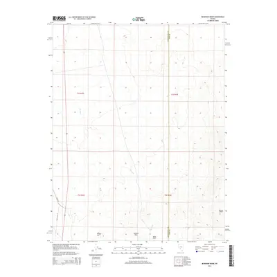
2014 Map of McMahon Ridge
USGS Topo · Published 2014About this map
McMahon Ridge and the surrounding high desert of the Great Basin define this topographical survey of central Nevada. The terrain is dominated by the volcanic forms of Kendall Mtn and Black Butte, which rise sharply above the southern landscape near the entrance to the Ralston Desert. Running through the center of the quadrangle, the prominent drainage of Big Wash illustrates the region’s hydraulic patterns, where seasonal runoff carves deep channels through the arid basin floor. Infrastructure in this remote area is sparse, consisting primarily of the north-south corridor of Us-95 and utility access via Power Line Rd. The boundary between Esmeralda and Nye counties bisects the eastern portion of the map, marking a political division in an otherwise continuous landscape of desert scrub and stony ridges.
Find a feature on this map
13 named features on this map. Tap any name to fly to it.
Don’t see what you’re looking for? This feature index may not catch every label — zoom into the map to look around manually.
Map Details
Editions of this 2014 McMahon Ridge Map
This is the sole edition of this map. No revisions or reprints were ever made.
Other maps of this area

1908 · Lida
USGS Topo · 1:250,000

1913 · Lida
USGS Topo · 1:250,000

1945 · Goldfield
USGS Topo · 1:125,000

1952 · Mud Lake
USGS Topo · 1:62,500

1952 · Goldfield
USGS Topo · 1:62,500

1954 · Goldfield
USGS Topo · 1:250,000

1955 · Goldfield
USGS Topo · 1:250,000

1958 · Goldfield
USGS Topo · 1:250,000

1962 · Goldfield
USGS Topo · 1:250,000
1970 · Klondike
USGS Topo · 1:24,000