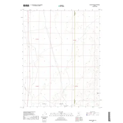
2018 Map of McMahon Ridge
USGS Topo · Published 2018About this map
McMahon Ridge and the volcanic prominence of Black Butte dominate this section of the Nevada desert landscape along the border of Esmeralda and Nye counties. This arid region, characterized by drainage channels like Big Wash, sits just east of the primary transportation corridor of Route 95. To the south, the terrain rises toward the slopes of Kendall Mtn, while the eastern portion of the sheet opens into the Ralston Desert. The map illustrates the sparse infrastructure typical of the Great Basin, where long-distance routes such as Silver Peak Rd provide the only access through large blocks of public land. The clear delineation of township and range lines, such as t1s r42e, highlights the geometric grid imposed on this complex, desert-mountain environment.
Find a feature on this map
12 named features on this map. Tap any name to fly to it.
Don’t see what you’re looking for? This feature index may not catch every label — zoom into the map to look around manually.
Map Details
Editions of this 2018 McMahon Ridge Map
This is the sole edition of this map. No revisions or reprints were ever made.
Other maps of this area

1908 · Lida
USGS Topo · 1:250,000

1913 · Lida
USGS Topo · 1:250,000

1945 · Goldfield
USGS Topo · 1:125,000

1952 · Mud Lake
USGS Topo · 1:62,500

1952 · Goldfield
USGS Topo · 1:62,500

1954 · Goldfield
USGS Topo · 1:250,000

1955 · Goldfield
USGS Topo · 1:250,000

1958 · Goldfield
USGS Topo · 1:250,000

1962 · Goldfield
USGS Topo · 1:250,000
1970 · Klondike
USGS Topo · 1:24,000