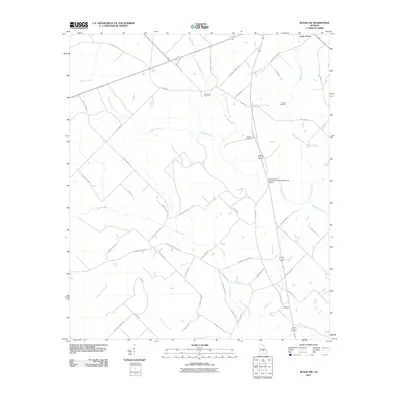
2011 Map of McRae NW
USGS Topo · Published 2011About this map
Cedar Grove and its surrounding rural landscapes in Laurens County are defined by a complex network of waterways that shaped local property lines and settlement patterns for generations. The terrain is crisscrossed by several significant drainages, including Gum Swamp Creek, Alligator Creek, and Whitewater Creek. The mapping of family-named burial grounds like Antioch Cemetery, Burch Cemetery, Harrelson Cemetery, and New Hope Cemetery provides vital clues for genealogists and local historians tracing the lineage of early area residents. The road network, often bearing the names of local figures such as George Parrot Rd, Monroe Butler Rd, and Clarence Chappell Rd, reflects the agricultural and familial ties of this Georgia community. A notable modern landmark, the Doctor Alfred Tennyson Coleman Memorial Bridge, stands as a dedicated point of crossing within this aquatic landscape.
Find a feature on this map
51 named features on this map. Tap any name to fly to it.
Don’t see what you’re looking for? This feature index may not catch every label — zoom into the map to look around manually.
Map Details
Editions of this 2011 McRae NW Map
This is the sole edition of this map. No revisions or reprints were ever made.
Other maps of this area

1957 · Macon
USGS Topo · 1:250,000

1958 · Macon
USGS Topo · 1:250,000

1964 · Macon
USGS Topo · 1:250,000

1970 · Scotland
USGS Topo · 1:24,000

1970 · Alamo
USGS Topo · 1:24,000

1972 · Mc Rae NW
USGS Topo · 1:24,000

1972 · Jay Bird Springs
USGS Topo · 1:24,000
1972 · Milan
USGS Topo · 1:24,000
1972 · Mc Rae
USGS Topo · 1:24,000

1973 · Cadwell
USGS Topo · 1:24,000