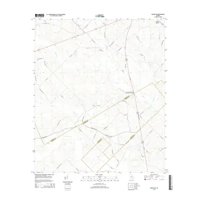
2014 Map of McRae NW
USGS Topo · Published 2014About this map
Cedar Grove sits at the northern edge of this rural Georgia landscape, where the headwaters of numerous creeks begin their southward flow toward the Ocmulgee and Oconee basins. This 2014 survey documents a complex network of waterways, including Alligator Cr, Joiner Cr, and Gum Swamp Creek, which define the low-lying terrain. The map serves as a detailed record of local family and community history, preserving the locations of several rural burial grounds such as Antioch Cem, New Hope Cem, and Burch Cem. In the southeastern portion, the Doctor Alfred Tennyson Coleman Memorial Bridge spans the wetlands where the borders of Laurens, Dodge, and Wheeler counties converge. The prevalence of named local routes, from Jaybird Springs Rd to Ella Burch Rd, reflects a landscape deeply tied to its agricultural and residential roots.
Find a feature on this map
65 named features on this map. Tap any name to fly to it.
Don’t see what you’re looking for? This feature index may not catch every label — zoom into the map to look around manually.
Map Details
Editions of this 2014 McRae NW Map
This is the sole edition of this map. No revisions or reprints were ever made.
Other maps of this area

1957 · Macon
USGS Topo · 1:250,000

1958 · Macon
USGS Topo · 1:250,000

1964 · Macon
USGS Topo · 1:250,000

1970 · Scotland
USGS Topo · 1:24,000

1970 · Alamo
USGS Topo · 1:24,000

1972 · Mc Rae NW
USGS Topo · 1:24,000

1972 · Jay Bird Springs
USGS Topo · 1:24,000
1972 · Milan
USGS Topo · 1:24,000
1972 · Mc Rae
USGS Topo · 1:24,000

1973 · Cadwell
USGS Topo · 1:24,000