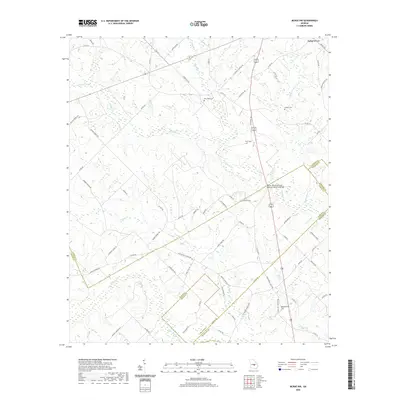
2020 Map of McRae NW
USGS Topo · Published 2020About this map
Cedar Grove sits at the northern edge of this landscape where Laurens, Dodge, Wheeler, and Telfair counties meet in a complex of rural boundaries. The terrain is defined by a dense network of waterways, including Alligator Creek and Gum Swamp Creek, which dictate the winding paths of local roads like Bertie Gay Rd and Ella Burch Rd. This 2020 survey reveals a quiet agricultural and timber-producing region where land ownership and community history are marked by family-named cemeteries and infrastructure. Notable local landmarks include New Hope Cem, Antioch Cem, and the Doctor Alfred Tennyson Coleman Memorial Bridge crossing Alligator Cr. The map preserves the specific locations of long-established burial grounds such as Burch Cem and Harrelson Cem, providing valuable spatial data for genealogists and local historians tracing the families of this four-county border region.
Find a feature on this map
77 named features on this map. Tap any name to fly to it.
Don’t see what you’re looking for? This feature index may not catch every label — zoom into the map to look around manually.
Map Details
Editions of this 2020 McRae NW Map
This is the sole edition of this map. No revisions or reprints were ever made.
Other maps of this area

1957 · Macon
USGS Topo · 1:250,000

1958 · Macon
USGS Topo · 1:250,000

1964 · Macon
USGS Topo · 1:250,000

1970 · Scotland
USGS Topo · 1:24,000

1970 · Alamo
USGS Topo · 1:24,000

1972 · Mc Rae NW
USGS Topo · 1:24,000

1972 · Jay Bird Springs
USGS Topo · 1:24,000
1972 · Milan
USGS Topo · 1:24,000
1972 · Mc Rae
USGS Topo · 1:24,000

1973 · Cadwell
USGS Topo · 1:24,000