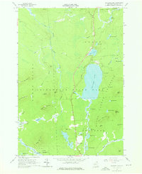
1964 Map of Meacham Lake
USGS Topo · Published 1976About this map
The East Branch St Regis River carves through this northern stretch of the Adirondack State Park, a landscape defined by an intricate network of wetlands, glacial ponds, and mountain peaks. Centered on the expansive Meacham Lake, the terrain shows a mid-century balance of conservation and recreation, featuring several Campground sites and a Picnic Area along the eastern shore. The settlement at McColloms serves as a lone pocket of development in the south, situated near McColloms Pond and the Osgood River. North of Daniel Mountain, a lonely Mine label suggests past industrial interest in these woods, while the surrounding State Forest Preserve ensures the protection of landmarks like Sugarloaf Mountain and Wolf Pond. The presence of a Gaging Station on the river near the lake indicates the ongoing hydrological management of these vital Adirondack headwaters during the early 1960s.
Find a feature on this map
58 named features on this map. Tap any name to fly to it.
Don’t see what you’re looking for? This feature index may not catch every label — zoom into the map to look around manually.
Map Details
Editions of this 1964 Meacham Lake Map
Other maps of this area

1902 · Saranac
USGS Topo · 1:62,500

1904 · Saranac
USGS Topo · 1:62,500

1905 · Saint Regis
USGS Topo · 1:62,500

1906 · Loon Lake
USGS Topo · 1:62,500

1908 · Loon Lake
USGS Topo · 1:62,500

1921 · Santa Clara
USGS Topo · 1:62,500

1923 · Santa Clara
USGS Topo · 1:62,500

1948 · Ogdensburg
USGS Topo · 1:250,000

1951 · Ogdensburg
USGS Topo · 1:250,000

1953 · Ogdensburg
USGS Topo · 1:250,000