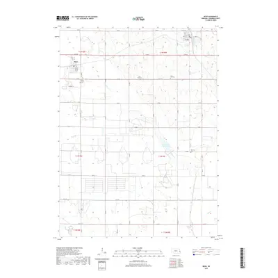
2017 Map of Mead
USGS Topo · Published 2017About this map
The agrarian landscape of Saunders County is anchored by the communities of Mead and Yutan in this modern-era survey. The map reveals a highly structured grid of county roads, such as Co Rd N and Co Rd M, that define the local township and range system. This rural topography is etched by several drainage systems, notably Clear Creek and Johnson Creek, the latter of which feeds into the Johnson Creek Reservoir 22-A. For those researching local heritage, the map identifies several burial grounds including Morning Side Cemetery and Saint James Cemetery, which stand as enduring landmarks of the region's settlement history. The southern reaches of the quadrangle are marked by the presence of Silver Creek and the beginnings of Wahoo Creek, illustrating the intricate network of tributaries that sustain this Nebraska farmland.
Find a feature on this map
32 named features on this map. Tap any name to fly to it.
Don’t see what you’re looking for? This feature index may not catch every label — zoom into the map to look around manually.
Map Details
Editions of this 2017 Mead Map
This is the sole edition of this map. No revisions or reprints were ever made.
Other maps of this area

1893 · Fremont
USGS Topo · 1:125,000

1896 · Fremont
USGS Topo · 1:125,000

1899 · Wahoo
USGS Topo · 1:125,000

1955 · Fremont
USGS Topo · 1:250,000

1957 · Fremont
USGS Topo · 1:250,000

1958 · Fremont
USGS Topo · 1:250,000

1968 · Valley
USGS Topo · 1:24,000
1968 · Ashland East
USGS Topo · 1:24,000

1968 · Leshara
USGS Topo · 1:24,000
1968 · Wann
USGS Topo · 1:24,000