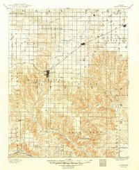
1892 Map of Meade
USGS Topo · Published 1949About this map
Meade serves as the focal point of this late 19th-century survey of the High Plains, situated where the Chicago Rock Island and Pacific Railroad cuts a diagonal path across the prairie. The landscape is defined by the winding course of Crooked Creek, which transitions from open tablelands into the more broken, dissected terrain of the southern townships. Smaller settlements like Fowler, Minneola, and Odee appear as modest hubs along the tracks or near vital water sources, reflecting the early stages of agricultural and rail-based expansion in the region. To the south, the Cimarron River forms a natural boundary, with the surrounding area marked by numerous dry washes and seasonal drainage patterns like Sand Creek. The map documents a period before modern irrigation, showing how early homesteaders clustered around reliable springs and the primary rail corridor.
Find a feature on this map
32 named features on this map. Tap any name to fly to it.
Don’t see what you’re looking for? This feature index may not catch every label — zoom into the map to look around manually.
Map Details
Editions of this 1892 Meade Map
5 editions found
Other maps of this area

1892 · Meade
USGS Topo · 1:125,000

1892 · Dodge
USGS Topo · 1:125,000

1892 · Spearville
USGS Topo · 1:125,000

1894 · Spearville
USGS Topo · 1:125,000

1896 · Garden
USGS Topo · 1:125,000

1896 · Ashland
USGS Topo · 1:125,000

1954 · Perryton
USGS Topo · 1:250,000

1955 · Woodward
USGS Topo · 1:250,000

1955 · Pratt
USGS Topo · 1:250,000

1955 · Dodge City
USGS Topo · 1:250,000