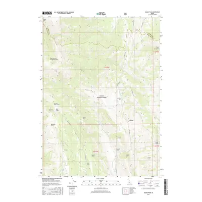
2017 Map of Meade Peak
USGS Topo · Published 2017About this map
Meade Peak and the Preuss Range dominate this high-elevation landscape within the Caribou National Forest along the Idaho-Wyoming border. This modern survey reflects the enduring geography of the Gannett Hills, where a complex network of canyons like Benninington Canyon and Snowside Canyon drain toward the Bear Lake and Caribou county lines. The map documents the persistent naming traditions of early settlers and ranching life, from the curiously named Giveout and Whiskey Flat to family-named landmarks such as Aegetter Hollow and Fisher Hollow. The region is defined by its drainage systems, notably Crow Cr and Montpelier Cr, which have historically dictated the placement of roads like Crow Creek Rd through these steep mountain passages.
Find a feature on this map
40 named features on this map. Tap any name to fly to it.
Don’t see what you’re looking for? This feature index may not catch every label — zoom into the map to look around manually.
Map Details
Editions of this 2017 Meade Peak Map
This is the sole edition of this map. No revisions or reprints were ever made.
Other maps of this area

1909 · Montpelier
USGS Topo · 1:125,000

1911 · Montpelier
USGS Topo · 1:125,000

1911 · Slug Creek
USGS Topo · 1:62,500

1915 · Crow Creek
USGS Topo · 1:62,500

1949 · Snowdrift Mountain
USGS Topo · 1:24,000
1951 · Snowdrift Mountain
USGS Topo · 1:24,000

1955 · Preston
USGS Topo · 1:250,000

1958 · Preston
USGS Topo · 1:250,000

1962 · Preston
USGS Topo · 1:250,000

1967 · Montpelier
USGS Topo · 1:24,000