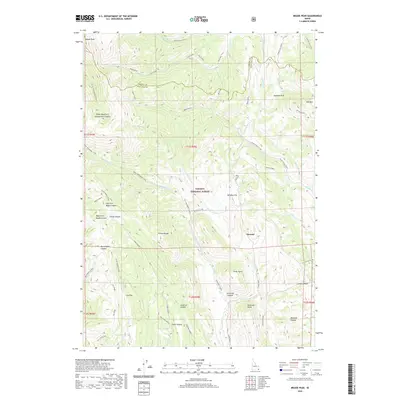
2020 Map of Meade Peak
USGS Topo · Published 2020About this map
Meade Peak and the high ridges of the Preuss Range dominate this corner of the Caribou National Forest along the border of Caribou and Bear Lake counties. The topography is defined by a series of deep canyons and named hollows, including Snowside Canyon, Bischoff Canyon, and Aegetter Hollow, which drain the mountainous terrain. The settlement of Giveout sits near Lower Pruess Creek, providing a rare point of reference in an otherwise vertical landscape of peaks like Snowside Point and Red Mountain. A complex network of drainage systems, such as Montpelier Creek and Crow Creek, carves through the Gannett Hills, illustrating the natural watershed patterns of the Idaho high country. Transportation is limited to rugged routes like Nat For Dev Rd 186 and the passage through Geneva Summit.
Find a feature on this map
56 named features on this map. Tap any name to fly to it.
Don’t see what you’re looking for? This feature index may not catch every label — zoom into the map to look around manually.
Map Details
Editions of this 2020 Meade Peak Map
This is the sole edition of this map. No revisions or reprints were ever made.
Other maps of this area

1909 · Montpelier
USGS Topo · 1:125,000

1911 · Montpelier
USGS Topo · 1:125,000

1911 · Slug Creek
USGS Topo · 1:62,500

1915 · Crow Creek
USGS Topo · 1:62,500

1949 · Snowdrift Mountain
USGS Topo · 1:24,000
1951 · Snowdrift Mountain
USGS Topo · 1:24,000

1955 · Preston
USGS Topo · 1:250,000

1958 · Preston
USGS Topo · 1:250,000

1962 · Preston
USGS Topo · 1:250,000

1967 · Montpelier
USGS Topo · 1:24,000