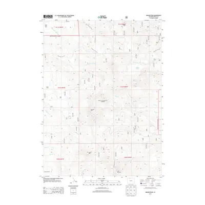
2013 Map of Meaden Peak
USGS Topo · Published 2013About this map
Diamond Peak and Meaden Peak dominate this high-altitude landscape within the Routt National Forest, where a network of trails and creeks defines the wilderness character of north-central Colorado. The presence of Jolley Ranch and Smith Ranch indicates the region's historical reliance on remote high-country ranching. These outposts sit among geographic landmarks like Nipple Peak and Sand Mountain, connected by primitive routes such as the Nipple Peak Trail 1147.1 and Prospector Trail 1156.1. A complex drainage system feeds into the S Fork Little Snake River and Elkhead Cr, punctuated by secluded water bodies like Willow Cr Lake. This era of the forest is captured through the detailed mapping of high parks, including Slater Park and California Park, illustrating the remote topography before modern intensive development changed the character of the Colorado backcountry.
Find a feature on this map
36 named features on this map. Tap any name to fly to it.
Don’t see what you’re looking for? This feature index may not catch every label — zoom into the map to look around manually.
Map Details
Editions of this 2013 Meaden Peak Map
This is the sole edition of this map. No revisions or reprints were ever made.
Other maps of this area

1911 · Hahns Peak
USGS Topo · 1:125,000

1913 · Hahns Peak
USGS Topo · 1:125,000

1923 · Pilot Knob
USGS Topo · 1:62,500

1925 · Pilot Knob
USGS Topo · 1:62,500

1954 · Craig
USGS Topo · 1:250,000

1957 · Craig
USGS Topo · 1:250,000

1958 · Craig
USGS Topo · 1:250,000

1960 · Craig
USGS Topo · 1:250,000

1962 · Craig
USGS Topo · 1:250,000
1962 · Tumble Mountain
USGS Topo · 1:24,000