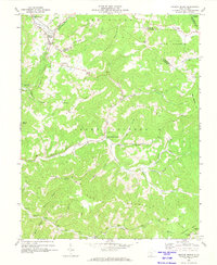
1969 Map of Meadow Bridge
USGS Topo · Published 1974About this map
Meadow Bridge serves as a primary settlement in this late 1960s landscape, situated where the Meadow River cuts through the high ridges of the Allegheny Plateau. The map reveals a deeply dissected terrain where communities are defined by narrow creek valleys and prominent heights like Patterson Mountain and Swell Mountain. Evidence of the region’s resource-based economy is visible near the northern border at the Tipple and Strip Mine, while the social fabric of these mountain hollers is marked by numerous country churches, including Little Meadow Ch and Lick Creek Ch.
Find a feature on this map
57 named features on this map. Tap any name to fly to it.
Don’t see what you’re looking for? This feature index may not catch every label — zoom into the map to look around manually.
Map Details
Editions of this 1969 Meadow Bridge Map
3 editions found
Other maps of this area

1887 · Hinton
USGS Topo · 1:125,000

1892 · Hinton
USGS Topo · 1:125,000

1912 · Meadow Creek
USGS Topo · 1:48,000

1912 · Big Bend
USGS Topo · 1:62,500

1914 · Big Bend
USGS Topo · 1:62,500

1915 · Meadow Creek
USGS Topo · 1:62,500

1921 · Alderson
USGS Topo · 1:48,000

1921 · Clintonville
USGS Topo · 1:48,000

1923 · Clintonville
USGS Topo · 1:62,500
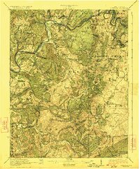
1923 · Alderson
USGS Topo · 1:62,500